Ground Penetrating Radar Surveys in the UK: Non-Destructive Utility Detection You Can Trust
Any project manager, architect, or engineer is familiar with the nightmare situation. You start to build, only to encounter an unexpected utility or subsurface risk that stops the work, increases the cost, and harms reputations. These risks are not exceptional, but the norm on UK construction and infrastructure projects, where hidden utilities and challenging ground conditions are a feature of nearly every site.
This is why Ground Penetrating Radar (GPR) surveys have become an anchor of safe and successful project delivery. By giving you a clear vision of what is beneath the surface without any destructive excavation, GPR enables you to proceed with confidence.
We excel at Intersect Surveys in delivering non-destructive, high-definition GPR surveys that expose concealed utilities and subsurface dangers. Our services empower architects, engineers, developers, and consultants to make sound decisions regarding risk reduction, planning more effectively, and protecting projects from time-consuming and cost-draining delays.
What Is Ground Penetrating Radar and Why It Matters
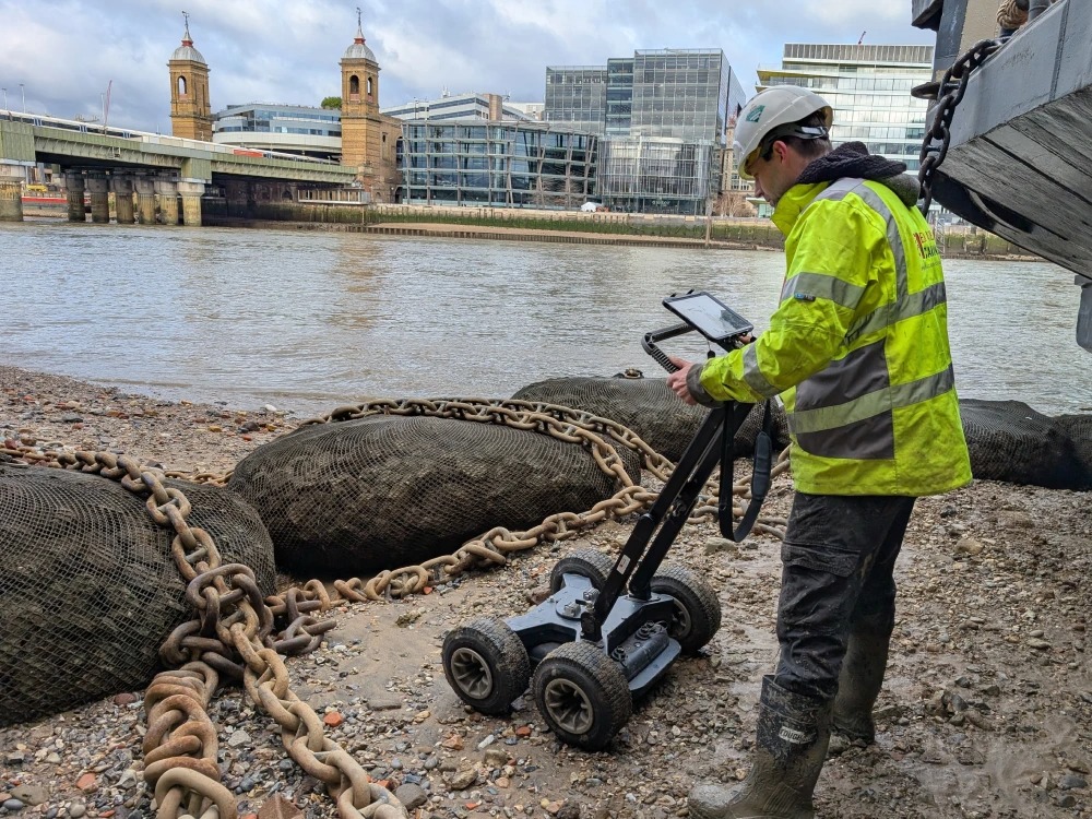
Ground Penetrating Radar (GPR) is a non-destructive survey technique that employs the use of radar pulses to identify objects, material variations, voids, and structures below the surface. Unlike conventional excavation or trial pits, GPR gathers information rapidly and with no site disturbance.
This technology is particularly significant for UK projects, where conditions below ground can be uncharted and range from aged infrastructure in London to countryside development sites. The risks are high, since one error with buried utilities can result in:
- Major safety risks to workers and the public
- Unexpected delays that set back project schedules by weeks or months
- Cost overruns that put pressure on budgets and investor confidence
- Legal and regulatory consequences if damage occurs
By investing in GPR surveys, project leaders gain peace of mind. They know exactly what is beneath their site before any construction begins.
How Ground Penetrating Radar Works
The technology underlying GPR is complex but simple to understand. Radio waves of high frequency are transmitted into the earth. When the waves strike buried objects or various layers of materials, they reflect back to a receiver. Sophisticated computer software interprets the reflections and generates reliable images of what is below the ground.
Key capabilities of GPR include:
- Detection of metal and non-metal utilities like water pipes, gas lines, electricity cables, and fibre optics
- Subsurface feature mapping like voids, foundations, and buried obstacles
- Locating rebar and structural elements in concrete scanning
- Producing high-resolution images that give planners and engineers clarity before breaking ground
The value lies in the detail. A good-quality GPR survey not only locates utilities but also their depth, orientation, and connection to the features around them. This will allow decisions to be made on realistic, actual data.
Why GPR Surveys Are Essential for UK Projects
Working in the UK presents unique challenges. Historic infrastructure, intricate subsurface utility networks, and crowded city conditions ensure that subsurface risk is ever-present. In London alone, it is estimated to have more than 1.5 million kilometres of underground utility pipes and cables, many of which are unmapped or incorrectly documented.
Skipping a GPR survey means gambling with your project. The consequences can include:
- Accidental strikes on utilities leading to public safety incidents
- Redesigns caused by unexpected obstructions
- Halted works while teams wait for emergency repairs
- Monetary losses due to fines, insurance claims, and lost hours
PAS128 standard surveys, performed by experts such as Intersect, give assurance that all investigations are to standards accepted for utility detection in the UK. Such compliance is essential for gaining planning permission, adhering to safety requirements, and delivering to customer specifications.
Why Choose Intersect for Ground Penetrating Radar Surveys
We do not just survey at Intersect; we are your project partners to success. Each property we set foot on is handled as if it were our own, because we know how much is invested when you’re developing, building, or planning. We are more than merely data collection; we aim at saving you from risk, cutting through ambiguity, and getting your project moving ahead on time.
What makes us stand out across the UK is not just the advanced technology we use, but the way we combine it with real-world expertise and genuine customer care. From the first conversation to the final delivery, we take time to listen, understand your unique challenges, and provide survey solutions that are practical, precise, and tailored to your needs. With Intersect, you’re not just hiring a survey company, you’re gaining a reliable partner who works alongside you to ensure every decision is backed by clarity and confidence.
Here is what sets us apart:
- State-of-the-art technology – We use the latest GPR equipment capable of producing high-resolution subsurface imaging for both shallow and deep investigations.
- Non-destructive surveys – Our work is designed to protect your site. We provide accurate data without disturbing the ground or interrupting existing services.
- PAS128 compliance – Every survey we conduct follows recognised industry standards for utility detection in the UK.
- Fast reporting – We deliver clear survey drawings and outputs quickly, helping you keep projects moving without unnecessary delays.
- Flexible services – Whether you are planning a small residential build or a major infrastructure project, we adapt our survey approach to meet your requirements.
- Expert team – Our surveyors bring years of experience across construction, infrastructure, and environmental projects, ensuring you get actionable insights, not just raw data.
With Intersect, you are not just buying a survey, you are securing a reliable partner who takes ownership of risk reduction and accurate planning.
Comprehensive GPR and Utility Detection Services
We offer a comprehensive suite of GPR and subsurface utility location solutions that extend well beyond the mere identification of what is buried below the ground. Our surveys are engineered to reveal the unknown, from concealed utilities and structures to possible hazards that can derange your project. By integrating advanced technology with skilled interpretation, we provide information that stakeholders in your project can rely on, share, and take action with confidence. The outcome is increased clarity earlier in the planning process, more streamlined cooperation among teams, and the reassurance that construction may proceed safely, efficiently, and without expensive surprises.
Our services include:
- Buried utility mapping – Accurate detection of metallic and non-metallic pipes, cables, and ducts.
- High-resolution subsurface imaging – Detailed radar scans that highlight potential hazards before excavation.
- PAS128 compliant surveys – Meeting recognised UK standards for utility detection.
- Concrete scanning – Identifying rebar, post-tension cables, and structural elements in existing concrete.
- Void detection – Locating underground voids or cavities that could compromise stability.
- Integration with other survey data – Delivering outputs in AutoCAD or digital formats that architects and engineers can immediately apply to designs.